My Travel and History Blog, Focussing mostly on Roman and Mediaeval Times
30 Mar 2018
Winter Night on Hardangervidda - From Oslo to Bergen by Train
I took the afternoon train from Oslo to Bergen, well aware that the last part of the journey would take place in darkness. But as it turned out, there was sleat later changing into rain once we passed the Hardangervidda, so I didn't miss much since the scenery would have been veiled by rain and fog anway.
The first part of the ride offered a mostly overcast sky and the long period of twilight typical for late March in the north. I managed to get some photos out of the moving train - a journey into winter indeed. Snow was piling up high on the Hardanger Plateau.

Lake Krøderen
Like the Dovre Railway, the Bergenbanan (Bergen Railway) was built in bits and pieces. The part from Bergen to Voss dates to 1883. There also was a railway from Oslo to Drammen since 1866. The whole single track line connecting those parts was finished in 1909. It covers a distance of almost 500 kilometes (310 miles), with some 180 tunnels and 300 bridges; the ride takes about seven hours.

Village at the Drammensfjord
The Drammenfjord is a firth of 30 kilometres length which confluences into the outer Oslofjord. It's main estuary is the Drammenselva (Drammen river). Until 2005, a double bridge of 340 respective 450 metres length crossed the river via an island at the town Drammen, but now a modern bridge of 1890 metres spans the entire river.
Shortly after passing the town, the sun decided to have a little peek out of the clouds and made for some lovely mix of water, snow and reflections.

Evening sun sparkling on the Drammenselva
Along Lake Krøderen, the Drammen river (about 50 kilomtres from Oslo) and on to Gol (200 km from Oslo) the rise is not significant, but past Gol the train climbs up to the Hardangervidda. At Geilo (250 km from Oslo) it already reaches 794 metres, and winter was truly setting in. Geilo is one of Norway's most popular skiing regions - no wonder when you look at that.

Holiday huts near Geilo
A few miles later the Hardangervidda begins and takes us up to 1,237 metres (4,050 ft.) above sea level near Finse. The original track led up to 1,300 metres, until the Finse tunnel was built in 1993, cutting through one of the worst part of the vidda. The railway moves above the treeline for about hundred kilometres, and there is a lot of snow. Really a lot - five to eight metres of the white fluff is considered normal, as are storms and snow drifts.
Part of the landscape here is actually a lake; the huts are situated at its shore. Those huts mostly have electricity and other amenities so they can be used in winter.

Holiday houses on the Hardangervidda
The Hardangervidda is the largest high plateau in Europe with an expanse of about 8,000 square kilometres, and a height between 1,200 to 1,400 metres above sea level (the mountain range Sandfloegga rises to 1,721 metres). One can imagine how difficult it proved to build a railway across the plateau, and how difficult it continues to be to keep the track clear of snow. Parts are covered by avalanche protections or run underground, but it still takes special rotating snow blasters running along the tracks from either Geilo or Myrdal to keep the traffic going. Back in the early 19th century, those were steam powered; today diesel is used.

Hardangervidda
A winter journey can be lovely, but I would like to take the tour in summer as well when one can admire the lakes and the Hardangerjøkulen (Hardanger Glacier), and the sparse, sub-arctic vegetation. There is a famous cycling and hiking way across the vidda, the Rallarvägen from Haugastøl to Flåm.

Haugastøl station
The railway station at Haugastøl (275 km from Oslo, 988 metres above sea level) is a fine example of station buildings with a stone walled first floor and a second half-storey made of timber - the only one along the railway that survives unaltered since 1908.
Below is the station and hotel of Finse with snow up to the second floor. That may be normal for my readers from some parts of the US, but I have never before seen that much snow in one place.

Finse station and hotel
After Finse, it was getting too dark to take decent photos, and the lights in the train were switched on. I decided to get me a prawn and egg sandwich from the bistro waggon and have a bit of dinner.

The train
The information in this article comes from a little guidebook the NSB Customer Service offered the guests of the railway: Oslo - Bergen. Die Bergenbahn.
¶ March 30, 2018 1 comments
I took the afternoon train from Oslo to Bergen, well aware that the last part of the journey would take place in darkness. But as it turned out, there was sleat later changing into rain once we passed the Hardangervidda, so I didn't miss much since the scenery would have been veiled by rain and fog anway.
The first part of the ride offered a mostly overcast sky and the long period of twilight typical for late March in the north. I managed to get some photos out of the moving train - a journey into winter indeed. Snow was piling up high on the Hardanger Plateau.
Like the Dovre Railway, the Bergenbanan (Bergen Railway) was built in bits and pieces. The part from Bergen to Voss dates to 1883. There also was a railway from Oslo to Drammen since 1866. The whole single track line connecting those parts was finished in 1909. It covers a distance of almost 500 kilometes (310 miles), with some 180 tunnels and 300 bridges; the ride takes about seven hours.
The Drammenfjord is a firth of 30 kilometres length which confluences into the outer Oslofjord. It's main estuary is the Drammenselva (Drammen river). Until 2005, a double bridge of 340 respective 450 metres length crossed the river via an island at the town Drammen, but now a modern bridge of 1890 metres spans the entire river.
Shortly after passing the town, the sun decided to have a little peek out of the clouds and made for some lovely mix of water, snow and reflections.
Along Lake Krøderen, the Drammen river (about 50 kilomtres from Oslo) and on to Gol (200 km from Oslo) the rise is not significant, but past Gol the train climbs up to the Hardangervidda. At Geilo (250 km from Oslo) it already reaches 794 metres, and winter was truly setting in. Geilo is one of Norway's most popular skiing regions - no wonder when you look at that.
A few miles later the Hardangervidda begins and takes us up to 1,237 metres (4,050 ft.) above sea level near Finse. The original track led up to 1,300 metres, until the Finse tunnel was built in 1993, cutting through one of the worst part of the vidda. The railway moves above the treeline for about hundred kilometres, and there is a lot of snow. Really a lot - five to eight metres of the white fluff is considered normal, as are storms and snow drifts.
Part of the landscape here is actually a lake; the huts are situated at its shore. Those huts mostly have electricity and other amenities so they can be used in winter.
The Hardangervidda is the largest high plateau in Europe with an expanse of about 8,000 square kilometres, and a height between 1,200 to 1,400 metres above sea level (the mountain range Sandfloegga rises to 1,721 metres). One can imagine how difficult it proved to build a railway across the plateau, and how difficult it continues to be to keep the track clear of snow. Parts are covered by avalanche protections or run underground, but it still takes special rotating snow blasters running along the tracks from either Geilo or Myrdal to keep the traffic going. Back in the early 19th century, those were steam powered; today diesel is used.
A winter journey can be lovely, but I would like to take the tour in summer as well when one can admire the lakes and the Hardangerjøkulen (Hardanger Glacier), and the sparse, sub-arctic vegetation. There is a famous cycling and hiking way across the vidda, the Rallarvägen from Haugastøl to Flåm.
The railway station at Haugastøl (275 km from Oslo, 988 metres above sea level) is a fine example of station buildings with a stone walled first floor and a second half-storey made of timber - the only one along the railway that survives unaltered since 1908.
Below is the station and hotel of Finse with snow up to the second floor. That may be normal for my readers from some parts of the US, but I have never before seen that much snow in one place.
After Finse, it was getting too dark to take decent photos, and the lights in the train were switched on. I decided to get me a prawn and egg sandwich from the bistro waggon and have a bit of dinner.
The information in this article comes from a little guidebook the NSB Customer Service offered the guests of the railway: Oslo - Bergen. Die Bergenbahn.
¶ March 30, 2018 1 comments
11 Mar 2018
A Trace of Spring in Dovrefjell - From Trondheim to Oslo by Train
I took the train from Trondheim to Oslo mid-April 2011 after the Hurtigruten voyage and managed to take some photos out of the moving train. The usual caveat for pictures taken out of a train or bus applies: there might be some reflections from the windows and slight blurs.

Kongsvoll Mountains
I traveled the Dovre Railway in the 'wrong' direction. When it was built, the first stage covered the way from Oslo to Eidsvoll and was the first railway in Norway (1854). The line was then built in bits and parts. The stretch between Søren and Trondheim dates to 1864, followed the connections between Eidsvoll - Hamar - Lillehammer etc., while the last part from Dombås to Søren - the original Dovre Railway which today gives the name to the entire route - was finished in 1921.

Melting ice on the river Driva
The railway follows the Mediaeval pilgrim's route from Oslo and surroundings to the cathedral and the shrine of St.Olav in Nidaros, as Trondheim was then called. The journey would take several days; the lake Mjøsa was crossed by boat in summer, and in winter the Dovrefjell was sometimes impassable at all. Today the journey takes about 6 hours.

Mountains in the Dovrefjell
The first mountain range some 150 kilometres south of Trondheim is the Kongsvoll (886 metres above sea level). The area is knows for a rich and varied mountain flora. The railway runs beside the river Driva (see photos above).

More mountains in the Dovrefjell
The Kongsvoll gives way to one of the larger mountain ranges in Norway, the Dovrefjell. The hightest point of the railway is at Hjerkinn, 1025 metres above sea level. The highest mountain, the Snøhetta, is even higher at 2286 metres. The Dovrefjell and the bogs at Fokstumyrene are rich in wildlife: moose, reindeer and musk ox can be found here. The site was declared a national park as early as 1923.

Bogs in Dovrefjell
The train then follows the river Gudbrandsdalslågen down to Lillehammer and Lake Mjøsa. The Gudbrandsdal (dal = valley) is a popular area for tourists who love nature and hiking. The river and its tributaries are fed from the glacier at Jotunheimen.

River Gudbrandsdalslågen
Lake Mjøsa is Norway's largest lake. It is 120 kilometres long (360 square km expanse) and the train follows its shore almost the entire way. Other than the fast running rivers which were busy thawing, most of the lake was still frozen, though I'm not sure if the ice still carried. It did on the lakes near Kirkenes, but that is a far way futher north.

Lake Mjøsa was still frozen
From Eidsvoll at the end of Lake Mjøsa it is about 70 km to the final destination: Oslo. I arrived in Oslo on a sunny and rather warm early afternoon, very different from the cold and overcast weather two weeks ago when I came from Copenhagen to stay a few hours before I took the train to Bergen. Spring had arrived in southern Norway.

The railway cuts through basalt cliffs near Oslo
I hope you liked the little tour through a part of Norway at a time of the year when the weather can change between winter and spring within a few hours.
Looks like the snow in the UK is mostly gone now as well. There was no snow where I live, but some really cold days. At least a bit of winter.

A thawing river
The information in this article comes from a little guidebook the NSB customer Service offered the guests of the railway: Dovrebanen Oslo - Trondheim - I pilegrimens fotspor, 2002.
¶ March 11, 2018 0 comments
I took the train from Trondheim to Oslo mid-April 2011 after the Hurtigruten voyage and managed to take some photos out of the moving train. The usual caveat for pictures taken out of a train or bus applies: there might be some reflections from the windows and slight blurs.
I traveled the Dovre Railway in the 'wrong' direction. When it was built, the first stage covered the way from Oslo to Eidsvoll and was the first railway in Norway (1854). The line was then built in bits and parts. The stretch between Søren and Trondheim dates to 1864, followed the connections between Eidsvoll - Hamar - Lillehammer etc., while the last part from Dombås to Søren - the original Dovre Railway which today gives the name to the entire route - was finished in 1921.
The railway follows the Mediaeval pilgrim's route from Oslo and surroundings to the cathedral and the shrine of St.Olav in Nidaros, as Trondheim was then called. The journey would take several days; the lake Mjøsa was crossed by boat in summer, and in winter the Dovrefjell was sometimes impassable at all. Today the journey takes about 6 hours.
The first mountain range some 150 kilometres south of Trondheim is the Kongsvoll (886 metres above sea level). The area is knows for a rich and varied mountain flora. The railway runs beside the river Driva (see photos above).
The Kongsvoll gives way to one of the larger mountain ranges in Norway, the Dovrefjell. The hightest point of the railway is at Hjerkinn, 1025 metres above sea level. The highest mountain, the Snøhetta, is even higher at 2286 metres. The Dovrefjell and the bogs at Fokstumyrene are rich in wildlife: moose, reindeer and musk ox can be found here. The site was declared a national park as early as 1923.
The train then follows the river Gudbrandsdalslågen down to Lillehammer and Lake Mjøsa. The Gudbrandsdal (dal = valley) is a popular area for tourists who love nature and hiking. The river and its tributaries are fed from the glacier at Jotunheimen.
Lake Mjøsa is Norway's largest lake. It is 120 kilometres long (360 square km expanse) and the train follows its shore almost the entire way. Other than the fast running rivers which were busy thawing, most of the lake was still frozen, though I'm not sure if the ice still carried. It did on the lakes near Kirkenes, but that is a far way futher north.
From Eidsvoll at the end of Lake Mjøsa it is about 70 km to the final destination: Oslo. I arrived in Oslo on a sunny and rather warm early afternoon, very different from the cold and overcast weather two weeks ago when I came from Copenhagen to stay a few hours before I took the train to Bergen. Spring had arrived in southern Norway.
I hope you liked the little tour through a part of Norway at a time of the year when the weather can change between winter and spring within a few hours.
Looks like the snow in the UK is mostly gone now as well. There was no snow where I live, but some really cold days. At least a bit of winter.
The information in this article comes from a little guidebook the NSB customer Service offered the guests of the railway: Dovrebanen Oslo - Trondheim - I pilegrimens fotspor, 2002.
¶ March 11, 2018 0 comments
3 Mar 2018
The Architecture of Scarborough Castle
After the tour through the earlier and later history of Scarborough Castle, let's have a closer look at some of the architectural features.

The barbican seen from the viewing platform;
the double D-shaped outer gate is to the left, the first bridge to the right
Since the castle is situated on a headland with steep cliffs (about 90 metres / 300 feet high) on three sides, there was only the landward side which needed additional protection. A double ditch was cut and curtain walls put up; the remains of the present ones date mostly from the 12th and early 13th centuries. The entrance was defended by a gatehouse with a double D-shaped tower on the land side, as well as two drawbridges (which today have been rebuilt in stone) and a walled-in walkway. There likely had been a portcullis, too.

Tower protecting the barbican bridge
The barbican, which is first mentioned in a source from 1175, has been altered considerably during the history of the castle. The tower protecting the walkway between outer gate and castle gate was built by King Henry III in 1243, for example. You can see the different stones: ashlar for the filling, and cut stones for the shell.

One of the wall towers seen from the outside
The curtain walls were futher protected by towers; 12 in all, which were added at different times. The towers along the inner bailey were hollow, allowing the insertion of two floors - with arrow slits - while the towers further toward the sea were solid with battlements on the top.

Interior of one of King John's towers
Several towers were added by King John; those are D-shaped, a 'modern' design for England at the time where most towers were still suqare. One of the towers in the inner bailey - albeit no longer standing to its full height - holds a viewing platform for the visitors of the castle which gives a fine view over the landward defenses.

King John's chambers with the keep in the background
King John also build what is refered to as King John's Chambers or Mosdale Hall; a two storeyed hall built against the townside curtain wall in the outer bailey. Only the basement survives today. The upper storey would have housed the royal appartments and maybe a chapel as well; the rooms were heated by fireplaces. The basement storey consisted of a hall and smaller chambers which probably were used by the household officials. The staircase was located in a tower adjacent the main building.

King John's Chambers aka Mosdale House, interior
The building was still in use at the time of King Henry III in the 1260ies. A document from the time of King Edward III says the Queen's chambers were located in the building (1361).
But the hall fell into ruins in the 16th century. It was briefly reused as barracks during WW1 when brick buildings were put up inside the remains, but those were destroyed and dismantled after the war.

Outer curtain wall seen from above, with the remains of Mosdale Hall
The inner bailey was once protected by its own curtain wall and ditch that separated it from the outer bailey, with two gates for access. Remains of wall and ditch can still be seen. Today, only the keep survives, but at the time of King Henry II the inner bailey included several more domestic buildings. Some of the stones in King John's Chambers were reused from the remains of those buildings which must have fallen into decay at an early stage.

The inner curtain walls
The rectangular keep, even in its ruinous state, still dominates the castle and appears on several of the photos I added in my prior posts. King Henry II put it on the highest spot of the headland where one could overlook the town and approach to the castle. The keep was built some time between 1159 and 1169; it was about 27 metres (90ft.) high, with walls that were up to 3.5 m (12ft.) thick.

King Henry's Norman keep, inside
The keep was erected on a sloping stone base and consisted of a basement and two additional storeys; the access was by a door in the first floor. The original staircase was housed in a tower, a forebuilding, which had two floors that did not correspond to the storeys of the main keep.
Originally, each corner of the keep proper had a turret overlooking the battlements which made it look even taller. Those battlements were higher than the countersunk roof of the quarters inside the walls (1). Countersunk roofs were rather common in Norman keeps; the fake walls hid the level of the actual roof in case of bombardements during a siege.

Interior of the keep, different angle
The present level of access is above the basement from where one can see the remains of the walls and window openings, as well as a fireplace. Some of the windows have scuncheon seats as you can see in the photo above (the uppermost window with the double arch).
Both first and second floor were divided into two rooms along the east-west range. Those walls contained one great arch on the first and three smaller ones on the second floor. Traces of those partition walls remain as well (see the first of the photos of the keep's interior here). The staircase, and latrines on both floors were hiding in the thick walls.
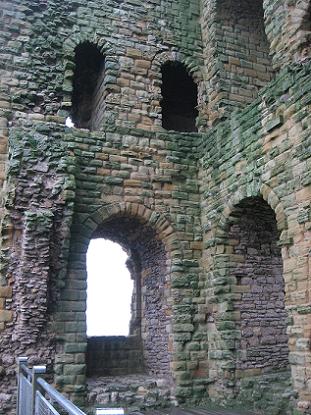
Another shot of the keep from the inside
The basement was used for storage. The first floor contained the great hall which was semi-separated by the arch. The chapel was a few stairs above hall level in the forebuilding. The second storey with the two rooms may have provided living quarters for the king, with the first room directly accessed from the staircase serving as a more official reception room and the second as his private quarters
The keep likely served as place for grand events during the entire Middle Ages even after King John built the living quarters at Mosdale Hall.

Barbican wall with merlons, Henry's Tower (middle),
and curtain walls seen from outside
Footnotes
1) It has formerly been assumed that there was an additonal storey, since there are traces of windows in the north wall, but any support for another floor is missing, as are fireplaces and hints to partition walls.
Literature
John A.A. Goodall: Scarborough Castle; English Heritage Guidebook, 2010
¶ March 03, 2018 2 comments
After the tour through the earlier and later history of Scarborough Castle, let's have a closer look at some of the architectural features.
the double D-shaped outer gate is to the left, the first bridge to the right
Since the castle is situated on a headland with steep cliffs (about 90 metres / 300 feet high) on three sides, there was only the landward side which needed additional protection. A double ditch was cut and curtain walls put up; the remains of the present ones date mostly from the 12th and early 13th centuries. The entrance was defended by a gatehouse with a double D-shaped tower on the land side, as well as two drawbridges (which today have been rebuilt in stone) and a walled-in walkway. There likely had been a portcullis, too.
The barbican, which is first mentioned in a source from 1175, has been altered considerably during the history of the castle. The tower protecting the walkway between outer gate and castle gate was built by King Henry III in 1243, for example. You can see the different stones: ashlar for the filling, and cut stones for the shell.
The curtain walls were futher protected by towers; 12 in all, which were added at different times. The towers along the inner bailey were hollow, allowing the insertion of two floors - with arrow slits - while the towers further toward the sea were solid with battlements on the top.
Several towers were added by King John; those are D-shaped, a 'modern' design for England at the time where most towers were still suqare. One of the towers in the inner bailey - albeit no longer standing to its full height - holds a viewing platform for the visitors of the castle which gives a fine view over the landward defenses.
King John also build what is refered to as King John's Chambers or Mosdale Hall; a two storeyed hall built against the townside curtain wall in the outer bailey. Only the basement survives today. The upper storey would have housed the royal appartments and maybe a chapel as well; the rooms were heated by fireplaces. The basement storey consisted of a hall and smaller chambers which probably were used by the household officials. The staircase was located in a tower adjacent the main building.
The building was still in use at the time of King Henry III in the 1260ies. A document from the time of King Edward III says the Queen's chambers were located in the building (1361).
But the hall fell into ruins in the 16th century. It was briefly reused as barracks during WW1 when brick buildings were put up inside the remains, but those were destroyed and dismantled after the war.
The inner bailey was once protected by its own curtain wall and ditch that separated it from the outer bailey, with two gates for access. Remains of wall and ditch can still be seen. Today, only the keep survives, but at the time of King Henry II the inner bailey included several more domestic buildings. Some of the stones in King John's Chambers were reused from the remains of those buildings which must have fallen into decay at an early stage.
The rectangular keep, even in its ruinous state, still dominates the castle and appears on several of the photos I added in my prior posts. King Henry II put it on the highest spot of the headland where one could overlook the town and approach to the castle. The keep was built some time between 1159 and 1169; it was about 27 metres (90ft.) high, with walls that were up to 3.5 m (12ft.) thick.
The keep was erected on a sloping stone base and consisted of a basement and two additional storeys; the access was by a door in the first floor. The original staircase was housed in a tower, a forebuilding, which had two floors that did not correspond to the storeys of the main keep.
Originally, each corner of the keep proper had a turret overlooking the battlements which made it look even taller. Those battlements were higher than the countersunk roof of the quarters inside the walls (1). Countersunk roofs were rather common in Norman keeps; the fake walls hid the level of the actual roof in case of bombardements during a siege.
The present level of access is above the basement from where one can see the remains of the walls and window openings, as well as a fireplace. Some of the windows have scuncheon seats as you can see in the photo above (the uppermost window with the double arch).
Both first and second floor were divided into two rooms along the east-west range. Those walls contained one great arch on the first and three smaller ones on the second floor. Traces of those partition walls remain as well (see the first of the photos of the keep's interior here). The staircase, and latrines on both floors were hiding in the thick walls.
The basement was used for storage. The first floor contained the great hall which was semi-separated by the arch. The chapel was a few stairs above hall level in the forebuilding. The second storey with the two rooms may have provided living quarters for the king, with the first room directly accessed from the staircase serving as a more official reception room and the second as his private quarters
The keep likely served as place for grand events during the entire Middle Ages even after King John built the living quarters at Mosdale Hall.
and curtain walls seen from outside
Footnotes
1) It has formerly been assumed that there was an additonal storey, since there are traces of windows in the north wall, but any support for another floor is missing, as are fireplaces and hints to partition walls.
Literature
John A.A. Goodall: Scarborough Castle; English Heritage Guidebook, 2010
¶ March 03, 2018 2 comments